Global Weather Under Threat as "Super" El Niño Officially Begins
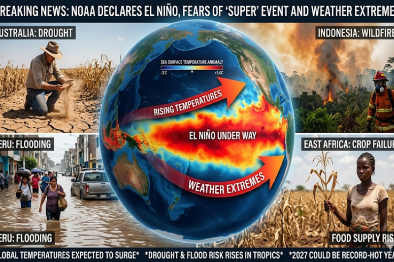
WASHINGTON — US scientists have officially declared the commencement of El Niño, a powerful, naturally occurring climate pattern in the Pacific Ocean that elevates global temperatures and threatens to unleash severe weather extremes across the planet.
The US National Oceanic and Atmospheric Administration (NOAA) confirmed that sea surface temperatures in the equatorial Pacific have spiked sharply, crossing the critical threshold of 0.5°C above the historical average.
Furthermore, shifts in atmospheric wind patterns indicate that the ocean and the atmosphere are now actively reinforcing one another.
Meteorological agencies around the globe are tracking the development closely. The Japan Meteorological Agency (JMA) joined NOAA in confirming the event's onset, projecting that it will persist at least through the autumn.
Meanwhile, Australia’s Bureau of Meteorology (BoM), which utilizes a stricter declaration threshold of 0.8°C above average, stated that the Pacific is "approaching El Niño conditions" and expects a formal onset later this year.
Fears of a "Super" El Niño Record
What has most alarmed climate researchers is the sheer speed and confidence with which computer models are predicting the intensity of this cycle.
An El Niño is classified as "strong" if ocean temperatures rise 1.5°C above average, and "very strong" if they exceed a 2°C increase. According to NOAA's latest data:
Historical Probability: There is a 63% chance that this system will develop into a "very strong" event between November and January.
Extreme Projections: Some advanced American and European predictive models suggest tropical Pacific temperatures could surge more than 3°C above normal by the end of the year.
If these models hold true, this system could rank alongside the most powerful "super" El Niño events ever recorded, such as those seen in 1982/83, 1997/98, and 2015/16.
Colliding with Global Warming
The major concern for scientists is that this intense climate pattern is arriving on a planet already severely warmed by human activity.
"The current El Niño is riding on top of a substantial amount of global warming," warned Professor Adam Scaife, head of monthly to decadal prediction at the UK Met Office. "This means that the actual temperatures in affected regions could well be unprecedented."
A potent El Niño typically pumps massive amounts of oceanic heat into the atmosphere, raising global air temperatures by roughly 0.2°C. Because the baseline temperature of the earth is already at record highs—with 2024 currently standing as the hottest year on record—this extra thermal boost could push global temperatures past dangerous thresholds.
Experts predict the full impact will culminate at the end of this year and persist deeply into 2027, potentially pushing global warming past 1.5°C above pre-industrial levels.
Impending Economic and Humanitarian Impacts
While El Niño events vary, their primary disruptions are felt most acutely across the tropics. The impending climate shift is expected to trigger a stark divide of weather extremes:
| Region | Expected Impact |
|---|---|
| Northern Peru, Southern Ecuador, East Africa, Central Asia, Southern US | Severe rainfall and flash flooding. |
| Australia, Indonesia, Northern South America, Central America | Severe droughts, failing crops, and intense wildfire risks. |
| The Atlantic Basin | Suppressed hurricane activity, leading to a quieter-than-average storm season. |
For vulnerable communities, the declaration is a matter of survival rather than science. Humanitarian groups warn that in regions like East Africa—which is already reeling from years of consecutive droughts and erratic flooding—the arrival of El Niño could decimate local agriculture, spike food prices, and push millions of families to the brink of starvation.